Saturday, March 31, 2012

South Maple Street Bridge, Enfield, CT

South Maple Street Bridge
This isn't the first time I missed a historical bridge and had to make do with the replacement, but in this case, I'm pretty happy about it. The previous South Maple Street Bridge was a low, pony truss bridge, one of many at this site. Its replacement, above, is something entirely new.

New for Connecticut, anyway.

This bridge was built in a factory in several locking pieces before it was brought to this site and assembled in place. The masonry at both ends of the bridge is a facade, molded into the concrete when it was poured on a factory floor. It's steel reinforced concrete through and through. This is the first bridge in the state to be entirely prefabricated offsite.

Old South Maple Street Bridge
I was in the area for the Scantic Spring Splash, an annual river race for kayaks and canoes down the Scantic River from Somers to Enfield. When I read the finish line was a bridge, it had to be my bridge of the week.


There was a shuttle bus between the Enrico Fermi High School and the Powder Mill Barn; those wishing to see the bridge when there isn't a race going on can likely park at Powder Mill Barn. There is also some parking at Powder Hollow Park, immediately adjacent and on the other side of the river. Plenty of family friendly hiking trails, and be sure to bring your dog. Everyone else does!

Sunday, March 25, 2012

Charter Oak Bridge, Hartford-East Hartford, CT

Charter Oak Bridge
It doesn't carry as much traffic as the Bulkeley Bridge, and it isn't the city centerpiece that Founders Bridge is, but the Charter Oak Bridge, the third (and newest) of Hartford's bridges across the Connecticut, has its own reasons to shine.

The Charter Oak that gave its name to the Hartford neighborhood where this bridge lands is a tree of legend in Connecticut. In 1662, the story goes, King James II decided that the colonies had had quite enough of this independence thing and appointed a governor, Edmund Andros, over the newly created Dominion of New England. When he arrived in Hartford to revoke Connecticut's charter, he was shown it, and then the candles blew out. When relit, the charter was gone -- hidden, it was said, in a huge oak tree, the Charter Oak, in south Hartford. In 1689, Andros was deposed and the Dominion of New England dissolved.

The original Charter Oak was split by lightning 150 years later, but its descendants live on, and the wood of the original tree was made into a chair which stands now in the State House.

Connecticut has always prided itself on its independence -- it was the first state to ratify the Constitution. The Charter Oak is Connecticut's symbol.

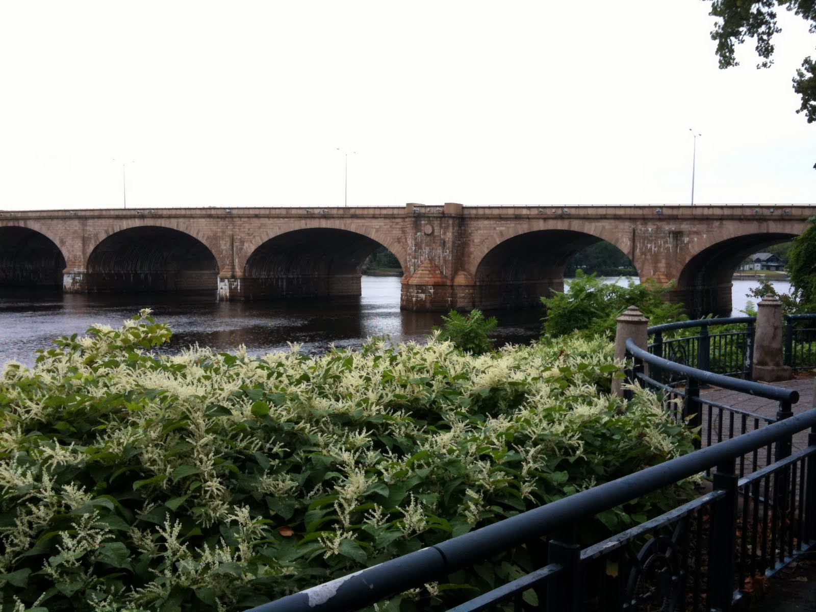
Charter Oak Bridge from the tour ship landing
The East Hartford side of the bridge stands in a small park which is (unfortunately) rather marshy. The Hartford side ends in Charter Oak Landing, the main dock for boats both personal and commercial in Hartford.  The Lady Katherine river tours leave from here. (The boat used to leave from Riverside Park near Founders Bridge, dunno why they moved down here). The public landing is on the south end of the park; the north end gives magnificent views of of the Colt Park section of Hartford (marked by the colorful dome on the old Colt Firearms factory) and of the Hartford skyline.

Charter Oak Landing
This picture may have been processed a little bit. I was having some fun with the new version of Picasa. You can see the Colt factory dome on the left of the photo.

Obligatory car shot
I don't honestly know how to get to the park in East Hartford. I've only been there on my bike, and I got there from the bridge itself, which features a wide, separated bike path on the north side. Charter Oak Bridge carries routes 5 and 15 over the river; following those signs will get you there. Or just click on the location information beneath this post and use Google Maps to get you there.

I've gotten to the end of this post without talking much about the bridge itself. You can see from the pictures that it's not all that special, a very modern girder bridge built with steel and concrete, similar to the East Windsor river crossing. It was built between 1988 and 1991 to replace an earlier bridge at the same point. Anyone going from I-84W to I-91S will cross the bridge and will never see the beautiful parks beneath it.

Sunday, March 18, 2012

Heublein Tower, Talcott Mountain State Park, Simsbury, CT

Heublein Tower
I have plenty of bridges waiting to be photographed, and some I have photographed but haven't yet written about. But I'm holding off a little. Spring has come to Connecticut and in a month or so the trees will be full of leaves. I'm just getting a little tired of taking photographs where all the trees are leafless. The northeast is getting dressed and when it's ready, I have bridges from Poughkeepsie to Providence to Portsmouth on the way.

I was going to photograph Hartford's Founders Bridge today, but the weather was so beautiful that I just drove past Hartford and headed to Bloomfield and up to Talcott Mountain State Park. I had this naive idea that it would be a quiet climb up the mountain. No way! The trails were crowded with moms, dads, kids and dogs all the way up and all the way back. Cars lined the road on both sides at the trail head.


My goal was the top of the mountain and Heublein Tower (pronounced HIGH-blayne). The tower sticks well above the trees and is visible for miles and miles all around the greater Hartford area. It was built by a German financier; the unusual pronunciation of the tower comes from an Anglicization of its German pronunciation, you see. He built the tower strong enough to withstand 100 mph winds. Apparently he didn't build it strong enough to withstand fire; it's been rebuilt a couple of times.

It's said presidents and diplomats have met here. Ronald Reagan visited the tower once. I bet none of them had to hike up.

 Parking at Talcott Mountain State Park is roadside; put on your emergency brake. There's a helipad at the end of the road for emergency transport of people who forgot to put on their emergency brakes, and for turning around when it's time to leave.

The path is wide enough for a car and well-packed all the way up. It's a little steep in places, but there are plenty of places to rest along the way, including vantage points from which can be seen stunning clifftop views of the Farmington River Valley.


The path divides occasionally into a steeper path that sticks more closely to the edge of the cliffs, and an easier path that delves further into the woods. Visitors uncomfortable with walking on the edge of a cliff may prefer that branch (but you're missing some awesome views!).

The tower itself is open from Memorial Day through October, and is known throughout the area as the place from which to view the autumn foliage in all its awesomeness. The park itself is open year round from dawn to sunset.

The park has many barbecue pits, fireplaces, picnic tables and paths to explore once at top. Standard hiking rules apply -- take out what you bring in.

Sunday, March 11, 2012

Ware-Hardwick Covered Bridge, Ware-Hardwick, MA

Ware-Hardwick Covered Bridge
The bad thing about wooden bridges is, they're only temporary. Truth is, all bridges are temporary; even today's bridges aren't meant to last much beyond 50 years without being totally reconstructed. New England's remaining covered bridges struggle to remain aloft until there's enough money and interest to get them renovated -- or torn down entirely for the public safety.

All of Connecticut's covered bridges have been rebuilt at least once; the Comstock covered bridge down in East Hampton is only the latest. The Bulls Bridge and West Cornwall Bridge are not the bridges they once were.

Neither is the Ware-Hardwick Covered Bridge, which crosses the Ware River in (wait for it) Ware, Massachusetts. It just finished a $3 million renovation in 2010; it had been closed off for years before then, unsafe to carry any load. The original latticework and outer walls were re-used, but the floor is wood over a sturdy steel frame, and the rafters are entirely new. The roof is now made of steel, an odd choice for a historic bridge.


I found names scratched into the latticework from 1938, and I'm sure I could have found earlier if I'd looked longer. Like most covered bridges that survive to this day, it doesn't take a lot of traffic. It's not an important bridge for traveling. It's an important bridge for connecting the community to its past.

I was more than a little shocked to hear, as I was talking with some guys walking along the Ware River as I was photographing the bridge, that the bridge might be moving to a new home in Vermont. Now, I don't have a dog in this fight. Connecticut's three covered bridges are being preserved. Vermont has seen its covered bridge number drop from 500 a hundred years ago to 100 now. Clearly it would like to acquire some replacements. Massachusetts, though, only has three covered bridges -- same as Connecticut.

Obligatory car and bridge shot
After spending all this money to renovate the bridge, they are talking about selling it? Madness. I couldn't find any confirmation of this on the web; I hope rumors is all this turns out to be.

The Ware-Hardwick bridge was designed based on patent by Ithiel Town, the architect who (by wild coincidence) designed the Bulls Bridge and West Cornwall Bridge. He charged one to two dollars per foot of bridge for the use of his patent.

I'm pretty sure the Town Bridge in Canton (last week's post) wasn't named after him, but who knows?

Wooden pegs hold the lattice together

Saturday, March 3, 2012

Town Bridge, Canton, CT

Town Bridge
This bridge was totally off my radar -- not surprising, since it's more than a little off the beaten path. I found word of it entirely by accident while reading another bridge blog (yes, there's more than just this one). The author of that blog was stunned by the historical importance of the bridge. It's a truss bridge constructed by the famous Berlin Iron Bridge Company which made dozens of bridges in the 19th century around Connecticut and elsewhere in the Northeast. He also got a much nicer picture of the bridge than I did.

Not making excuses. It snowed recently, and I thought it would make a nice picture. I took my chances on a rainy day. What the heck, it was a nice drive through foggy mountain passes.


The real star here is the Farmington River. The river is a recreation center in Hartford County; a long system of well-maintained trails and paved paths follows the river through some of the most beautiful scenery in New England. Not far from the Town Bridge is a huge parking lot that forms the springboard for boating, bicycling, hiking and fishing. The parking lot on even a rainy late winter day was far from empty.

We Yankees love the outdoors. When you live someplace like Connecticut, who can blame us?

Friday, March 2, 2012

Bulkeley Bridge, East Hartford-Hartford, CT

Bulkeley Bridge from Great River Park, East Hartford
I have to accept that I never will take the "perfect" picture of Bulkeley Bridge. This bridge is made from thousands of shaped stones, and I believe is the longest stone arch bridge in the world. It carries I-84 over the Connecticut River between Hartford and East Hartford. There's a pedestrian walkway along the south side of the bridge, just recently repaired. The bridge condition was getting pretty dire.


It's not easy to get a good sense for how massive this bridge is from pictures alone. You have to get close enough to see all the individual carved stones that make up the bridge and just try to imagine the work that must have gone into each one. They fit together perfectly. I took the top picture last weekend with my DSLR camera; I took the one just above this paragraph a couple years ago with a Samsung point and shoot.


This one I took last summer, after Hurricane Irene decimated the forests that line the Connecticut River and the debris was left to drift downstream, to fetch up against the Bulkeley. You can see just how high the river had risen after the storm.


This is the very first picture I took of the bridge. I'd been driving on top of it for a couple of years, but had never stopped to see what the bridge actually looked like. The stone of the bridge changes character with the light.

The Bulkeley Bridge is the center of river recreation in both cities; the parks on both sides are filled with sculptures, paths, boat landings and such. An "after Independence Day" celebration takes place on the Hartford side each year; sometimes they put colored lights under the arches and light them at night (haven't managed to catch that in advance, yet).


A view of the north side of the bridge, from Riverside Park. Done with really faky HDR before I knew what I was doing. The first picture in this posting is also HDR, but in the year or so since I took this picture, I've figured out about balancing the exposure levels between the composite shots and stuff. Doesn't mean the picture is any good, but at least everything is the correct hue and luminance. Some people have figured out how to do crazy HDR that looks totally unearthly. I don't necessarily WANT to do that -- those photographs tend to be so noisy I can barely figure out what the picture is of -- but I'd like to have that tool in my toolbox to make my pictures look more abstract.

Anyway. Plenty of parking on both sides of the bridge, though on the Hartford side you're more likely to be made to pay. I don't remember if you have to pay to park in the boathouse parking lot.

If you ever come to Hartford, take time out to visit the Bulkeley Bridge. Come when there's something going on and make a day of it. When Hartford puts its mind to it, it's a really nice city.